

Delimitation Map 2025
🗺️ 2025 Ward Delimitation • GIS MAP
Adat Grama Panchayat
Ward Map
Official interactive ward map of Adat Grama Panchayat prepared based on the 2025 ward delimitation.
01
2025 Ward Delimitation
This is the official GIS-based ward map prepared as part of the 2025 ward delimitation procedures for local self-government institutions in Kerala. This map helps the public understand ward boundaries and check regional details.
02
Ward Information
01
Chittilappilly Western Muri
02
Chittilappilly Eastern Muri
03
Kannikulam
04
Chittilappilly Ground
05
Mullappoonthadam
06
Choorakkattukara
07
Ramanchira
08
Muthuvara
09
Ambakkad
10
Puthissery
11
Vilangan
12
Puranattukara
13
Parikkad
14
Vilakkungal
15
Sanskrit College
16
Manidam
17
Udalakkavu
18
Kunnumpuram
19
Ambalankavu
20
Adat
03
Panchayat Boundaries
North
Kaiparamba Panchayat
West
Venkitangu, Tholur Panchayats
🧭
Adat Grama Panchayat Panchayat Boundaries
East
Thrissur Corporation, Kolazhy Panchayat
South
Thrissur Corporation, Arimbur Panchayat
04
Interactive Ward Map
GIS-Based Official Ward Map Adat Grama Panchayat • Thrissur
05
Key Features of the Map
Ward Boundaries
Revised ward boundaries based on the 2025 delimitation are visualized on the map.
Interactive Navigation
Zoom into the map, locate areas, and examine various locations.
GIS Technology
Accurate geospatial information is made available to the public based on GIS.
06
How to Use the Ward Map
01 • Select Ward Find the required area on the interactive GIS map and check the relevant ward.
02 • Zoom Map Zoom in on the map for more detailed geospatial information of the area.
03 • Check Boundaries Examine the ward boundaries based on the 2025 delimitation.
04 • View Official Notice Check the official PDF notification regarding delimitation via the link above.
07
Adat Grama Panchayat Ward Map
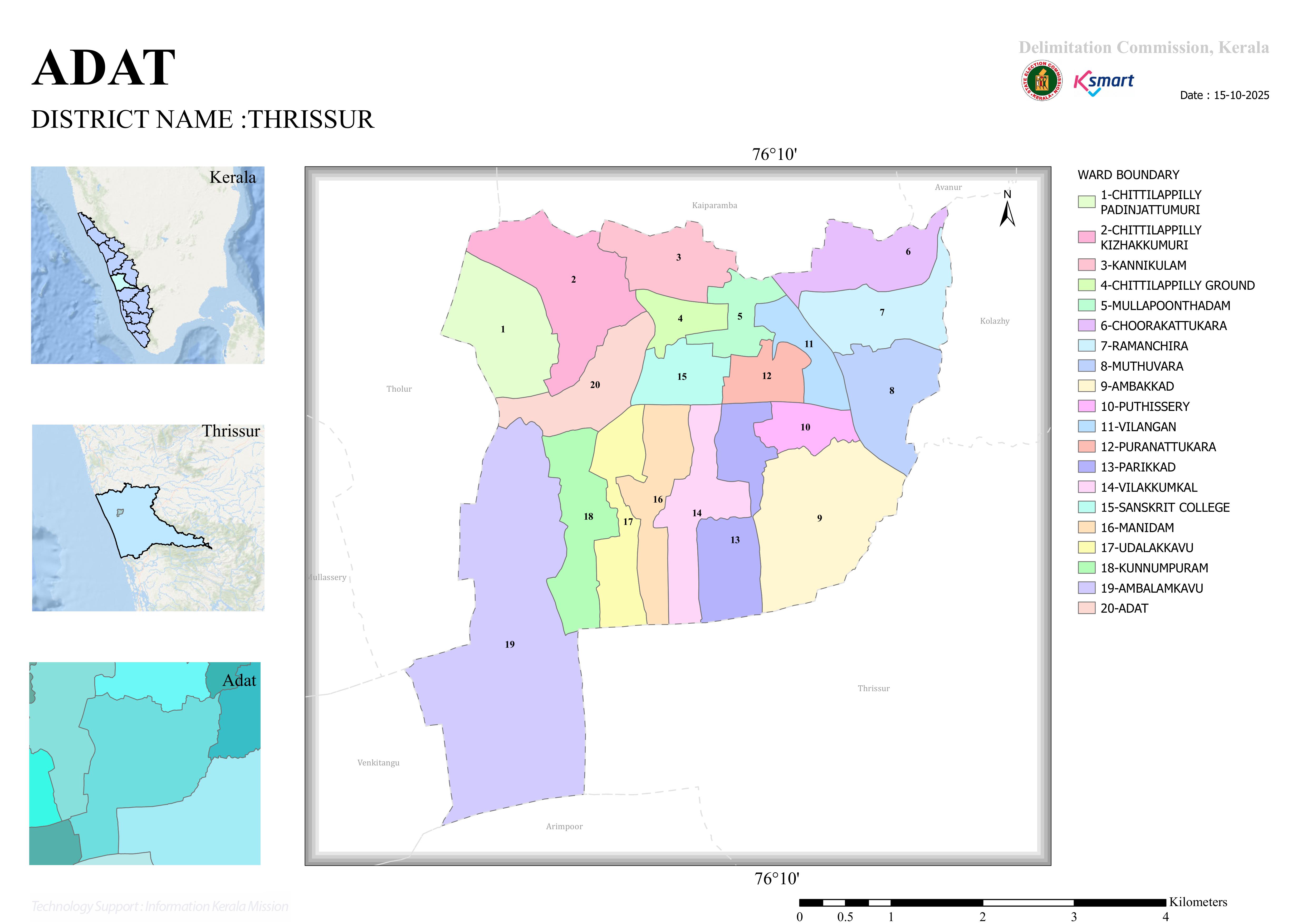
Ward Map of Adat Grama Panchayat based on the 2025 Ward Delimitation
Note: If the interactive map is not visible within the website due to certain browser security restrictions, please use the “Open in Fullscreen” button.